LANDMARKLOCATION OBJECTS
NOTE: This object is not available when the Scenery Editor is in World Hub Mode.
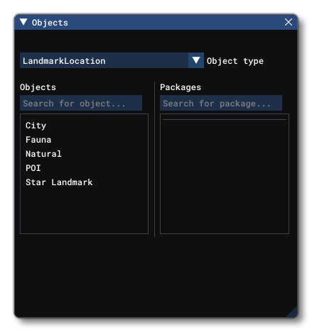
An LandmarkLocation object is an object element used to add information to the simulation about a specific landmark, and you can select one of multiple types of object element from the Objects window:
- City: This marks a particular city. Landmark cities are only shown on the World Map.
- Fauna: This marks an area of fauna. Landmark fauna areas are shown on the World Map and in the world during a flight.
- Natural: This is for marking some natural phenomenon or area. Landmark natural areas are only shown on the World Map.
- POI: This marks a "Point Of Interest". Landmark POI are shown on the World Map and in the world during a flight.
- Star Landmark: This marks a special landmark with a "Star" marker. Landmark star points are shown on the World Map and in the world during a flight.
Once you have chosen a type of Landmark Location object to create, you can click Add to add it to the scene then position it where required using the Gizmo. Note that setting the height (altitude) of the object using the translation gizmo is independent of the Height Offset value (from the Properties), which will be added to the height set using the gizmo.
Properties
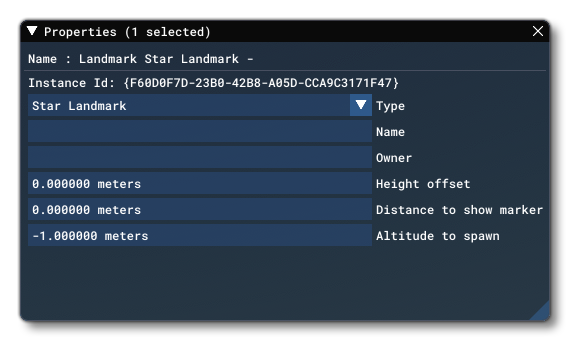
The Properties window for a Landmark Location looks like this:
-
Name (display)
This is the name of the element as defined from its type and the Name given to it.
-
Instance ID
This shows the unique GUID for this specific instance of the object element.
-
Type
Here you can change the type of Landmark object that it is: City, Fauna, Natural, POI or Star Landmark.
-
Name (input)
This is the name of the landmark that will be displayed on the World Map before a flight. Note that this field in obligatory and must be included otherwise you'll have an error in the Scenery Editor.
-
Owner
The "owner" can be the name of the user that is creating the asset or a company name. Note that this field in obligatory and must be included otherwise you'll have an error in the Scenery Editor.
-
Height Offset
This is an offset value (in meters) for the height (altitude) of the in-sim marker for the Landscape Location. This can be used to avoid any overlap with other scenery markers and the value will be added on to the height set using the gizmo in the scene when the object was added.
-
Distance To Show Marker
This sets the distance from the user aircraft outside of which the landmark marker will not be shown.
NOTE: This is currently not used and setting the value will have no visible effect.
-
Altitude To Spawn
This sets the altitude above the ground at which the user aircraft will be spawned when the POI has been selected from the world map as the departure point. Set to -1 to use the default altitude.
NOTE: This is currently not used and setting the value will have no visible effect.